上海大学学报(自然科学版) ›› 2021, Vol. 27 ›› Issue (2): 260-270.doi: 10.12066/j.issn.1007-2861.2291
• 中国西南地区河流拦截对物质循环的影响及生态意义 • 上一篇 下一篇
符俊杰1,2,3, 王伟3, 李伟3, 孙君瑶3( )
)
收稿日期:2021-03-21
出版日期:2021-04-30
发布日期:2021-04-27
通讯作者:
孙君瑶
E-mail:sunjunyao@wbgcas.cn
作者简介:孙君瑶(1987—), 女, 博士, 研究方向为湖泊水生植物大尺度数据分析. E-mail:sunjunyao@wbgcas.cn基金资助:
FU Junjie1,2,3, WANG Wei3, LI Wei3, SUN Junyao3()
Received:2021-03-21
Online:2021-04-30
Published:2021-04-27
Contact:
SUN Junyao
E-mail:sunjunyao@wbgcas.cn
摘要:
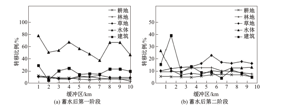
土地利用变化与人为干扰密切相关. 河流筑坝改变了库区周边土地利用的类型和覆盖, 影响了陆地生态系统通过内陆水体向海洋进行物质输送的过程. 以乌江六冲河洪家渡水库为例, 通过土地利用转移矩阵分析, 在流域尺度和景观尺度探讨了洪家渡水库建设对六冲河洪家渡流域内土地利用变化的影响. 结果表明: ① 在时间尺度上, 土地利用变化主要发生在蓄水后第二阶段; 蓄水后第一阶段洪家渡水库流域总体变化为耕地面积减少 91.33 km$^{2}$, 林地、草地、水体、建筑面积分别增加 26.54, 8.84, 55.51, 0.45 km$^{2}$; 蓄水后第二阶段总体变化为耕地、林地、草地面积分别减少 230.98, 30.17, 42.88 km$^{2}$, 水体、建筑面积分别增加 9.07, 295.46 km$^{2}$; ② 在空间尺度上, 土地利用变化主要集中在洪家渡水库附近, 表现为耕地面积减少、草地面积增加; 在库区景观尺度上, 洪家渡水库筑坝后淹没了不同类型的土地形成库区, 0$\sim$1 km 缓冲区范围内土地利用类型变化最大, 主要表现为水体转移为草地, 建筑转移为耕地.
中图分类号:
符俊杰, 王伟, 李伟, 孙君瑶. 河流筑坝对流域和景观尺度土地利用变化的影响——以洪家渡水库为例[J]. 上海大学学报(自然科学版), 2021, 27(2): 260-270.
FU Junjie, WANG Wei, LI Wei, SUN Junyao. Impact of dam construction on land-use change at the catchment and landscape scale: a case study of Hongjiadu Reservoir[J]. Journal of Shanghai University(Natural Science Edition), 2021, 27(2): 260-270.

图1
洪家渡水库流域地理位置示意图"
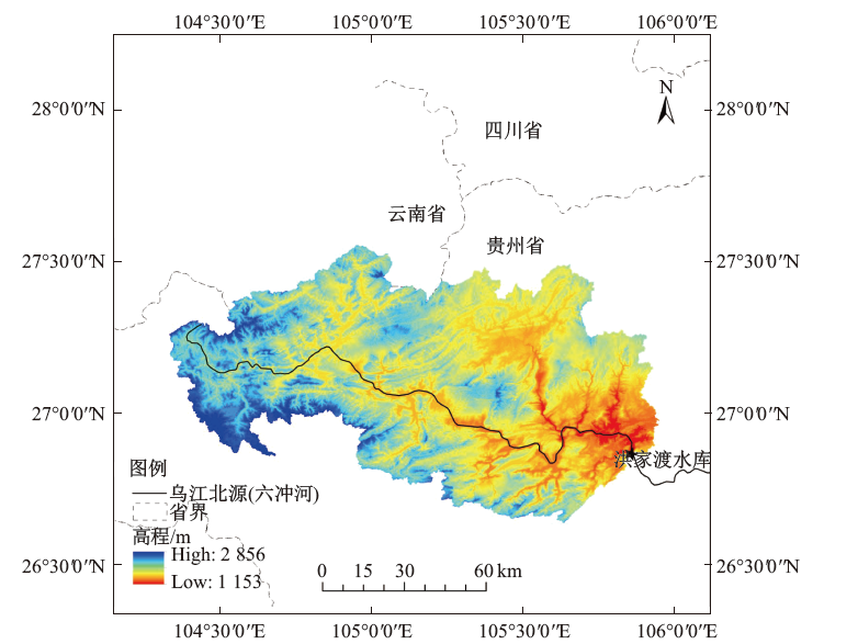
表1
2020 年洪家渡水库流域土地利用面积和占比"
 |
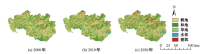
图2
2000$\sim$2020 年洪家渡水库流域土地利用类型分布图"

表2
2000$\sim$2020 年洪家渡水库流域土地利用面积变化幅度"
 |
表3
蓄水后第一阶段洪家渡水库流域土地利用转移矩阵"
 |
表4
蓄水后第二阶段洪家渡水库流域土地利用转移矩阵"
 |
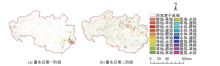
图3
2000$\sim$2020 年洪家渡水库流域土地利用转移矩阵分布图"

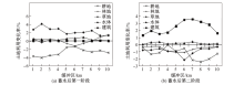
图4
2000$\sim$2020 年洪家渡水库 0$\sim$10 km 缓冲区土地利用面积变化比例"
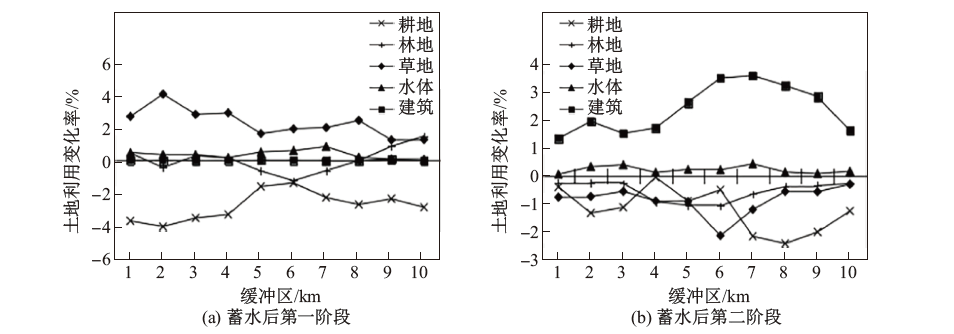
图5
2000$\sim$2020 年洪家渡水库 0$\sim$10 km 缓冲区土地利用面积转移比例"
| [1] | Wei G L, Yang Z F, Cui B S, et al. Impact of dam construction on water quality and water self-purification capacity of the Lancang River, China[J]. Water Resources Management, 2009,23(9):1763-1780. |
| [2] | Lu X X, Oeurng C, Le T P, et al. Sediment budget as affected by construction of a sequence of dams in the lower Red River, Viet Nam[J]. Geomorphology, 2015,248:125-133. |
| [3] | Gehrke P C, Gilligan D M, Barwick M. Changes in fish communities of the Shoalhaven River 20 years after construction of Tallowa Dam, Australia[J]. River Research and Applications, 2010,18(3):265-286. |
| [4] |
Ezcurra E, Barrios E, Ezcurra P, et al. A natural experiment reveals the impact of hydroelectric dams on the estuaries of tropical rivers[J]. Science Advances, 2019. DOI: 10.1126/sciadv.aau9875.
pmid: 33888467 |
| [5] |
Mendonüa R, Müller R A, Clow D, et al. Organic carbon burial in global lakes and reservoirs[J]. Nature Communications, 2017,8:1694.
pmid: 29162815 |
| [6] |
Maavara T, Lauerwald R, Regnier P, et al. Global perturbation of organic carbon cycling by river damming[J]. Nature Communications, 2017,8:15347.
pmid: 28513580 |
| [7] | 李晓晴, 王伟, 操瑜, 等. 水库消落带碳氮输移转化研究进展 [J/OL]. [2021-03-19]. http://kns.cnki.net/kcms/detail/32.1118.P.20201105.1106.002.html. |
| Li X Q, Wang W, Cao Y, et al. Research advances in transport and transformation of carbon and nitrogen in water-level fluctuating zone (WLFZ) of reservoir [J/OL]. [2021-03-19]. http://kns.cnki.net/kcms/detail/32.1118.P.20201105.1106.002.html. | |
| [8] | Vannote R L, Minshall G W, Cummins K W, et al. The river continuum concept[J]. Canadian Journal of Fisheries and Aquatic Sciences, 1980,37:130-137. |
| [9] | Kelly V J. Influence of reservoirs on solute transport: a regional-scale approach[J]. Hydrological Processes, 2001,15(7):1-23. |
| [10] | 刘丛强, 汪福顺, 王雨春, 等. 河流筑坝拦截的水环境响应——来自地球化学的视角[J]. 长江流域资源与环境, 2009(4):86-98. |
| Liu C Q, Wang F S, Wang Y C, et al. Responses of aquatic environment to river damming: from the geochemical view[J]. Resources and Environment in the Yangtze Basin, 2009(4):86-98. | |
| [11] | Sun J Y, Hunter P D, Cao Y, et al. Response of terrestrial net primary productivity (NPPT) in the Wujiang catchment (China) to the construction of cascade hydropower stations[J]. Inland Waters, 2018,8(2):239-253. |
| [12] | Xu X B, Tan Y, Yang G S, et al. Impacts of China's Three Gorges Dam Project on net primary productivity in the reservoir area[J]. Science of the Total Environment, 2011,409(22):4656-4662. |
| [13] | 周涛, 程天雨, 虞宁晓, 等. 乌江中上游梯级水库氮磷滞留效应[J]. 生态学杂志, 2018,37(3):707-713. |
| Zhou T, Cheng T Y, Yu N X, et al. Nitrogen and phosphorus retention in cascade reservoirs along the upper reaches of Wujiang River[J]. Chinese Journal of Ecology, 2018,37(3):707-713. | |
| [14] | 王万发, 钟君, 李彩, 等. 喀斯特地区梯级水库建造对水化学分布的影响[J]. 湖泊科学, 2020,32(3):713-725. |
| Wang W F, Zhong J, Li C, et al. The influence of cascade reservoir construction on water chemistry distribution in karst area[J]. Journal of Lake Sciences, 2020,32(3):713-725. | |
| [15] | 王尧, 蔡运龙, 潘懋. 贵州省乌江流域土地利用与土壤侵蚀关系研究[J]. 水土保持研究, 2013,20(3):11-18. |
| Wang Y, Cai Y L, Pan M. Analysis on the relationship between soil erosion and land use in Wujiang River basin in Guizhou Province[J]. Research of Soil and Water Conservation, 2013,20(3):11-18. | |
| [16] |
Li Z W, Xu X L, Xu C H, et al. Dam construction impacts on multiscale characterization of sediment discharge in two typical karst watersheds of Southwest China[J]. Journal of Hydrology, 2018. DOI: 10.1016/j.jhydrol.2018.01.034.
doi: 10.1016/j.jhydrol.2018.10.038 pmid: 32020949 |
| [17] | 牛潜, 周旭, 许幼霞, 等. 基于土地利用的贵州省乌江流域生态系统服务价值演变分析[J]. 生态科学, 2018,37(5):165-173. |
| Niu Q, Zhou X, Xu Y X, et al. Analysis of ecosystem service value evolution of Wujiang River basin of Guizhou Province based on land use[J]. Ecological Science, 2018,37(5):165-173. | |
| [18] | 陈歆, 靳甜甜, 苏辉东, 等. 拉萨河河流健康评价指标体系构建及应用[J]. 生态学报, 2019,39(3):799-809. |
| Chen X, Jin T T, Su H D, et al. Construction and application of health assessment index system for Lhasa River[J]. Acta Ecologica Sinica, 2019,39(3):799-809. | |
| [19] | 张勇荣, 周忠发, 蒋翼, 等. 筑坝河流不同尺度土地利用结构对库区水质的影响——以平寨水库为例[J]. 水利水电技术, 2019,50(4):138-145. |
| Zhang Y R, Zhou Z F, Jiang Y, et al. Effects of multi-scale land use structure on water quality of damming rivers: a case study of Pingzhai Reservoir[J]. Water Resources and Hydropower Engineering, 2019,50(4):138-145. | |
| [20] | 李屹峰, 罗跃初, 刘纲, 等. 土地利用变化对生态系统服务功能的影响——以密云水库流域为例[J]. 生态学报, 2013,33(3):726-736. |
| Li Q F, Luo Y C, Liu G, et al. Effects of land use change on ecosystem services: a case study in Miyun Reservoir watershed[J]. Acta Ecologica Sinica, 2013,33(3):726-736. | |
| [21] | He X B, Wang M F, Tang Q, et al. Decadal loss of paddy fields driven by cumulative human activities in the Three Gorges Reservoir area, China[J]. Land Degradation $\&$ Development, 2020,31:1990-2002. |
| [22] | 李辉, 张晓媛, 国洪磊. 基于土地利用的三峡库区近 30 年生态系统服务价值时空变化特征[J]. 水土保持研究, 2021,28(2):309-318. |
| Li H, Zhang X Y, Guo H L. Spatial and temporal changes of ecosystem service value in the Three Gorges Reservoir area in the past 30 years based on land use[J]. Research of Soil and Water Conservation, 2021,28(2):309-318. | |
| [23] | 徐丰, 曹宏, 廖章志. 遥感技术在开发建设项目水土保持监测中的应用——以洪家渡水电站为例[J]. 中国水土保持, 2008(3):42-44, 64. |
| Xu F, Cao H, Liao Z Z. Application of remote sensing technique to the monitoring of soil and water conservation of development projects[J]. Soil and Water Conservation in China, 2008(3):42-44, 64. | |
| [24] | 喻元秀, 刘丛强, 汪福顺, 等. 洪家渡水库溶解二氧化碳分压的时空分布特征及其扩散通量[J]. 生态学杂志, 2008(7):1193-1199. |
| Yu Y X, Liu C Q, Wang F S. Spatiotemporal characteristics and diffusion flux of partial pressure of dissolved carbon dioxide (pCO$_2$) in Hongjiadu Reservoir[J]. Chinese Journal of Ecology, 2008(7):1193-1199. | |
| [25] | 刘纯军, 周国富, 黄启芬, 等. 基于地形梯度的贵州乌江流域土地利用时空演变分析[J]. 贵州师范大学学报(自然科学版), 2020,38(6):45-54. |
| Liu C J, Zhou F G, Huang Q F, et al. Spatial-temporal evolution of land use in Wujiang River basin in Guizhou Province based on the terrain gradient[J]. Journal of Guizhou Normal University (Natural Sciences), 2020,38(6):45-54. | |
| [26] | 刘纯军, 周国富, 黄启芬, 等. 基于 InVEST 模型的西南山地流域生境质量时空分异—— 以贵州赤水河流域为例 [J/OL]. [2021-03-19]. http://kns.cnki.net/kcms/detail/42.1202.TV.20210204.1836.002.html. |
| Liu C J, Zhou F G, Huang Q F, et al. Spatio-temporal evolution analysis of habitat quality in the mountainous watershed of southwest based on InVEST model: a case study of Chishui River basin in Guizhou Province [J/OL]. [2021-03-19]. http://kns.cnki.net/kcms/detail/ 42.1202.TV.20210204.1836.002.html. | |
| [27] | 王业春, 雷波, 张晟. 三峡库区消落带不同水位高程植被和土壤特征差异[J]. 湖泊科学, 2012,24(2):206-212. |
| Wang Y C, Lei B, Zhang C. Differences in vegetation and soil characteristics at different water-level altitudes in the drawdown areas of Three Gorges Reservoir area[J]. Journal of Lake Science, 2012,24(2):206-212. | |
| [28] | Shields J F, Andrew S, Lyle J S. Reservoir effects on downstream river channel migration[J]. Environmental Conservation, 2000,27(1):54-66. |
| [1] | 张力, 宋一超, 蒲韵竹, 倪聪聪, 邓宁, 黄鑫. 水源地除藻围隔拦截效果与机制分析[J]. 上海大学学报(自然科学版), 2026, 32(2): 324-332. |
| [2] | 杨子韬, 王良军, 朱文浩, 丁虎, 张武. 单层缓冲区多层网格的格子Boltzmann方法[J]. 上海大学学报(自然科学版), 2023, 29(3): 473-. |
| [3] | 黄佳琦, 林昕, 汪福顺, 马静. 乌江流域下游梯级水库沉积物中木质素的特征及有机碳来源辨析[J]. 上海大学学报(自然科学版), 2021, 27(2): 271-279. |
| [4] | 关天昊, 李晓东, 王亦尧, 杨梦迪, 崔高仰, 丁士元, 张雪程. 喀斯特地区深水型水库重金属分布特征、影响因素及来源——以龙滩水库为例[J]. 上海大学学报(自然科学版), 2021, 27(2): 236-249. |
| [5] | 梅林, 范新怡, 岳一鸿, 刘留, 褚永胜, 汪福顺. 基于 FTIR 对水库沉积物中 TOC, TN 和 BSi 含量的快速测定[J]. 上海大学学报(自然科学版), 2021, 27(2): 227-235. |
| [6] | 张金华, 黄佳琦, 林昕, 汪福顺, 马静. 乌江流域颗粒态有机碳的时空分布特征[J]. 上海大学学报(自然科学版), 2021, 27(2): 250-259. |
| [7] | 岳一鸿, 傅志伟, 陈学萍, 杨明, 王宝利, 汪福顺. 乌江流域某水库浮游藻类群落结构及多样性分析[J]. 上海大学学报(自然科学版), 2021, 27(1): 97-105. |
| [8] | 苏青青, 郦春蓉, 王先云, 张东, 黄鑫. 藻团2维投影特征值定量水源水库中优势藻种[J]. 上海大学学报(自然科学版), 2020, 26(6): 980-988. |
| [9] | 刘烨, 王玉洁, 汪福顺, 梁霞, 陈学萍, 杨明, 马静. 多环芳烃在新安江河流-水库体系表层沉积物中的分布、来源及生态风险评估[J]. 上海大学学报(自然科学版), 2020, 26(1): 113-122. |
| [10] | 吴明红, 王扶琳, 杨雪霞, 史茗歌, 徐刚. 上海地区水环境中邻苯二甲酸酯类污染物的浓度水平及分布特征[J]. 上海大学学报(自然科学版), 2016, 22(2): 105-113. |
| [11] | 钱慧君, 高洋, 操满, 傅家楠, 马静, 汪福顺. 水坝拦截对新安江沉积物中磷、氮形态的影响[J]. 上海大学学报(自然科学版), 2015, 21(1): 72-80. |
| [12] | 李晓东, 刘小龙, 杨周, 李亲凯, 黄俊. 嘉陵江梯级水库群溶解无机碳同位素的时空变化特征[J]. 上海大学学报(自然科学版), 2015, 21(03): 286-293. |
| [13] | 张靖1, 刘小龙2, 高洋1, 姜艳兴1, 李双1, 罗文芸1, 汪福顺1. 百花水库水质模拟及季节性水质恶化控制对策[J]. 上海大学学报(自然科学版), 2013, 19(5): 441-447. |
| [14] | 余飞,丁国际,郑乐平,穆莉,张明. 赣江上游流域丰水期大型底栖动物群落的分布特征[J]. 上海大学学报(自然科学版), 2012, 18(4): 419-424. |
| 阅读次数 | ||||||
|
全文 |
|
|||||
|
摘要 |
|
|||||